AI analysis of a 1513 Ottoman map reveals hidden patterns suggesting lost Columbus data embedded within the famous Piri Reis chart.
When artificial intelligence was applied to the 1513 Piri Reis map, researchers expected inaccuracies typical of early navigation. Instead, the analysis revealed structured coastline alignments and layered geographic sources. The data suggested that the map was not a single creation, but a carefully assembled compilation built from multiple earlier charts.
The algorithm separated the map into mathematical clusters, identifying differences in projection styles. Certain regions followed geometric rules that did not match Ottoman mapping traditions. These inconsistencies hinted that parts of the chart originated from external sources, potentially much earlier than the final 1513 compilation.
 Courtesy of Tatyana Sigaryova | Pinterest
Historians have long known that Piri Reis referenced numerous maps in his notes. However, the AI findings showed that these sources were not blended randomly. Instead, they appeared organized by accuracy and geographic reliability, indicating deliberate selection and integration.
One cluster stood out. The coastline of South America matched descriptions associated with early Atlantic exploration. Combined with linguistic analysis of place-names, the data pointed toward a possible connection with charts produced during the earliest voyages to the Americas.
The Enigmatic Origins of the Map
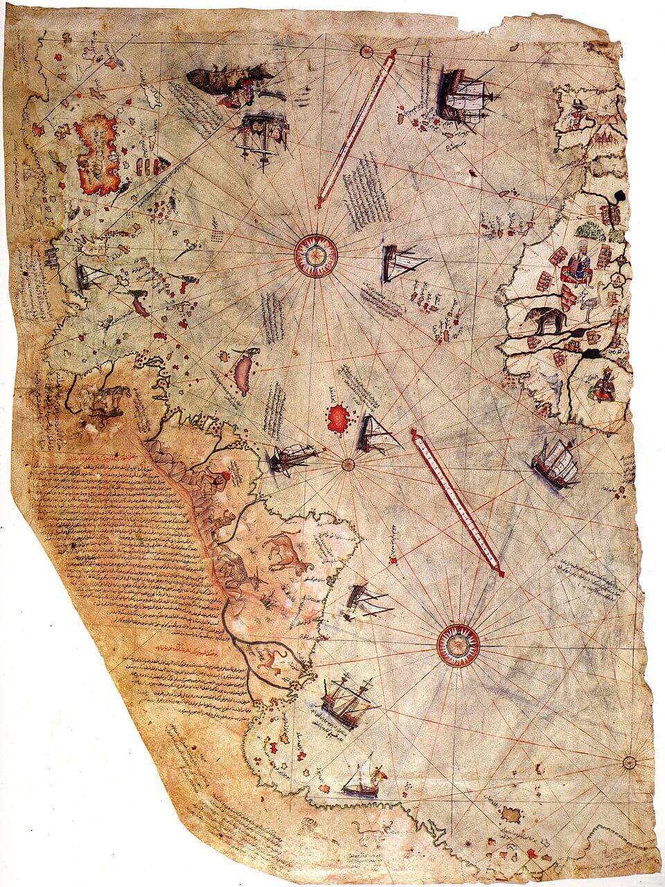
The 1513 chart emerged during a period of intense maritime exploration. Piri Reis himself wrote that he used around twenty sources, including Portuguese charts and possibly one linked to early Spanish expeditions. These notes have long been considered crucial to understanding the map’s construction.
Artificial intelligence strengthened this interpretation by identifying distinct mapping layers. The Caribbean region reflected early navigation routes, while parts of South America displayed surprising precision for the era. These findings suggest that the map integrated first-hand exploration data.
Such structured compilation indicates that Piri Reis was not simply copying information. He was evaluating and selecting the most reliable geographic knowledge available to him, preserving details that might otherwise have disappeared.
How Artificial Intelligence Was Applied
Researchers digitized the entire map in extremely high resolution. The AI measured coastline curvature, angle relationships, and projection distortions. These were compared against known cartographic methods from the fifteenth and sixteenth centuries.
The system also examined place-name chronology. Certain labels corresponded to early Spanish terminology that later changed, suggesting that some information came from the first phase of Atlantic exploration.
By combining geometric and linguistic analysis, the AI grouped segments likely originating from the same unknown source. These clusters showed patterns consistent with early exploration-era charts.
Geometric Patterns That Shouldn’t Exist
The analysis identified projection consistency across specific coastline segments. These geometric relationships are rarely found in Ottoman navigation charts but align with early Atlantic mapping approaches.
Distance spacing between islands also reflected travel estimates recorded in early voyage logs. This consistency implies access to navigational measurements derived from real expeditions.
Such alignment suggests that Piri Reis incorporated high-quality geographic data, rather than relying solely on secondary reports.
The Columbus Connection
Historical records indicate that charts from early voyages circulated among sailors. Copies may have been exchanged, captured, or shared across maritime networks. This makes it possible that a chart linked to early Atlantic exploration reached Ottoman hands.
The AI comparison showed proportional similarities between coastline sections and estimates derived from early navigational notes. These patterns support the theory that part of the map derived from a lost exploration-era source.
If accurate, the Piri Reis map may preserve geographic information otherwise lost to history.
Why No Early Charts Survived
Maps from the early sixteenth century were highly vulnerable to damage. Fire, humidity, and frequent travel often destroyed documents. Many navigation charts simply deteriorated over time.
Strategic secrecy also played a role. Governments treated maps as valuable assets, limiting their circulation. Outdated charts may have been discarded once new discoveries were made.
Fragments copied into later compilations sometimes survived. This may explain how information persisted within the Piri Reis map.
The Role of Ottoman Cartography
Ottoman naval tradition encouraged collecting foreign geographic knowledge. Captured ships and shared intelligence expanded available mapping sources.
Piri Reis operated within this environment. His compilation reflects diverse influences, combining Mediterranean, Portuguese, and Spanish information.
Such cross-cultural exchange increased the likelihood that early exploration data reached Ottoman cartographers.
Conspiracy Theories vs. Analytical Evidence
The map has long inspired speculation about advanced civilizations and unknown technologies. These theories gained popularity but lacked empirical support.
AI analysis provides a grounded explanation. The accuracy may stem from high-quality Renaissance-era sources rather than extraordinary origins.
This interpretation shifts the mystery from speculation to historical reconstruction.
What This Means for History
The findings suggest that early exploration knowledge circulated more widely than previously believed. Maps may have shared data across political and cultural boundaries.
The discovery also demonstrates how modern technology can reveal hidden layers in historical artefacts. Digital analysis offers new tools for understanding early cartography.
The Piri Reis map may represent only one example of preserved geographic knowledge waiting to be rediscovered.
Conclusion: The Chart That Kept Its Secret
The 1513 map stands as a reminder that history often survives in fragments. Artificial intelligence did not rewrite the past, but it revealed connections hidden within centuries-old ink. The possibility that lost exploration data survives inside the chart transforms it into a bridge between eras.
What makes the discovery compelling is how long the clues remained unnoticed. Scholars studied the map for generations, yet only modern analysis exposed its layered construction. This suggests that other historical documents may contain similar hidden structures.
The Piri Reis map continues to challenge assumptions about early navigation. Its lines may still hold unanswered questions, quietly preserving knowledge that only now begins to emerge.